Patuxent River

My husband and I enjoyed the PAXCON Reflections (the webinars provided in lieu of the Patuxent River Conference this year). The recordings are now posted to the website (link above) and available to all. The topics include:

How climate is changing in the Chesapeake Bay region and the Patuxent River watershed, potential impacts to Patuxent River water quality, and how communities can prepare for the future

The importance of wetlands in the Chesapeake Bay Region

Stormwater and how local communities are working to restore their streams and meet regulatory requirements

I’ve been prompted by these webinars to think about my own connection to the Patuxent River close to where I live. The Middle Patuxent originates in Howard County and joins the Little Patuxent near Savage, MD which continues southeast to join the Patuxent River just before it crosses under Crain Highway just south of Crofton, MD. There are 5 locations where I’ve been at or in the Middle Patuxent in recent years. The first 4 are sites for volunteer gigs (pre-pandemic) with high school students assessing water quality. Use the Google Map starting at MPEA and follow the Middle Patuxent.

MPEA

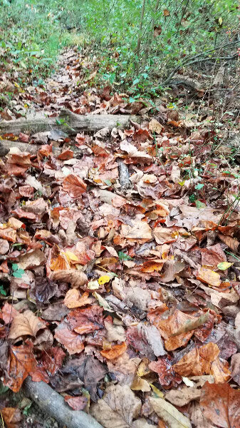
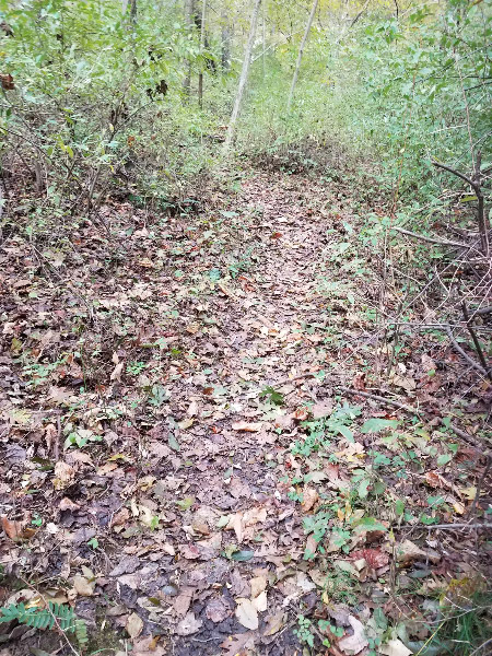
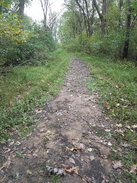
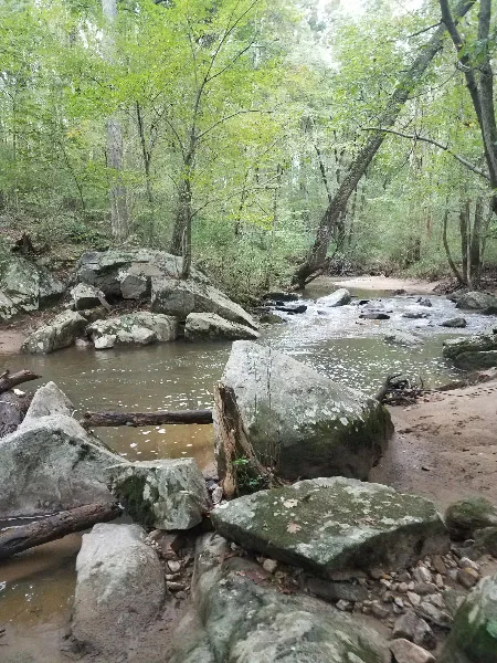
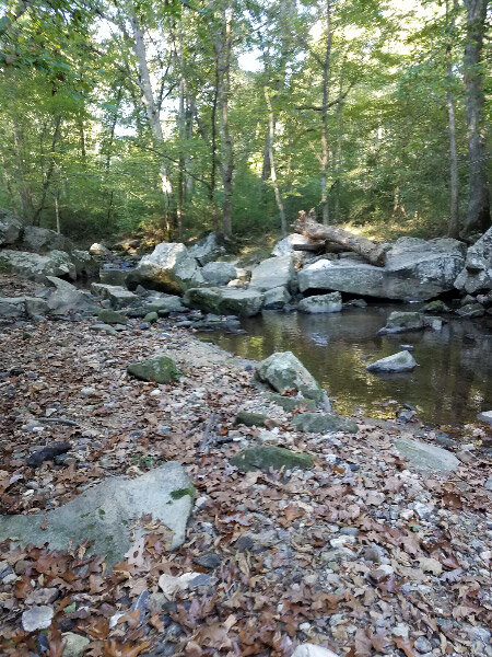
Middle Patuxent Environmental Area is near the origin of the Middle Patuxent. There are several streams that come together in the area to form the river. A loop of the Southwind Trail that goes close to the river. There are a lot of rocks in and along the river…riffles and runs and pools…places for lots of critters.

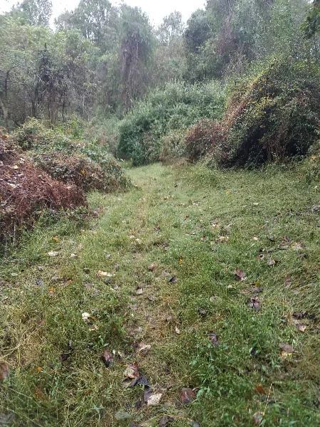
One time I went down when it was raining – the trail too muddy and the river too high for the water quality sampling. The runoff water had some foam in it and the speed of the water demonstrated how the banks eroded with each such event (note the leaning tree at the edge of the water.)

Robinson Nature Center

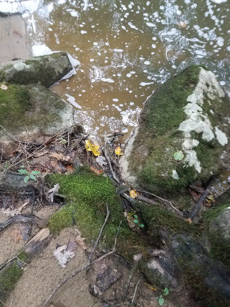
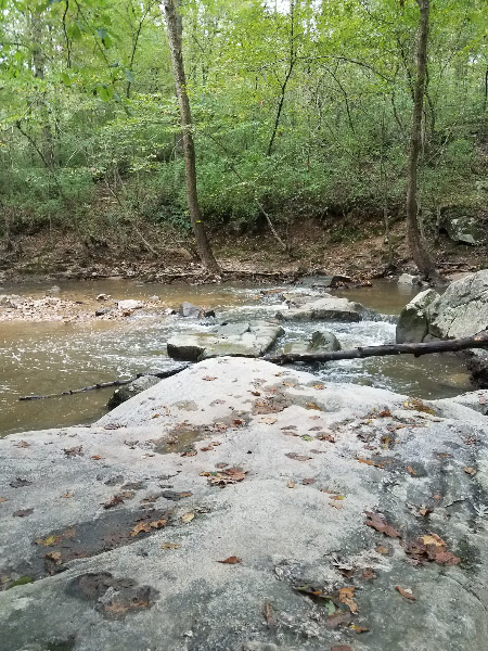
Robinson Nature Center is a little further down river from MPEA. I did water quality monitoring with other adults at that location pre-pandemic. There is more water in the channel than at MPEA. The trees along the river are smaller and don’t shade the water…making the water warmer that it was prior to the surrounding development. The banks are somewhat incised but there are still some beach areas…riffles, pools, and runs. There is more silt as well. There are still a few big rocks in the river. Note the whale shaped rock!

Edenbrook

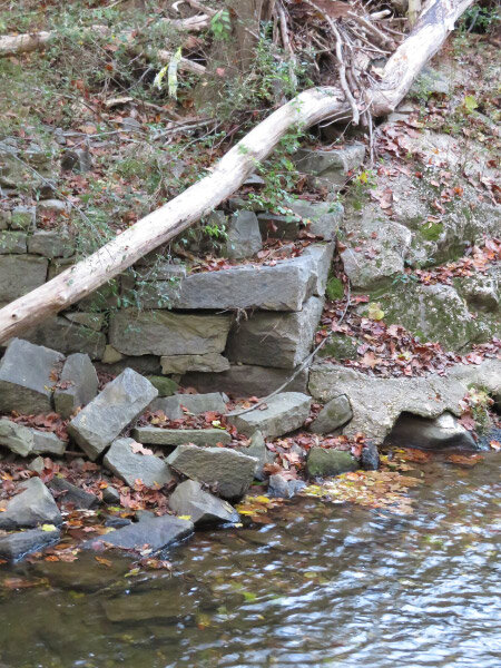
The Middle Patuxent flows under Columbia Pike and on through suburbia. Parking at the dead end of Edenbrook Drive near Kings Contrivance and walking down the old road (gated) to the river is another access point. There use to be a bridge over the river that connected to Kindler Road on the south side. It washed away years ago, but the abutments are still along the river. The banks are more incised. The river is disconnected from its flood plain by this point (it has cut a deep enough channel that it doesn’t broaden much even when there is a lot of water: the water just flows faster and the channel just gets deeper).

Sweet Hours Way

2019 10 IMG_5783.jpg

Parking on Sweet Hours Way and taking the Kings Contrivance Loop trail down to the rive is a little scenic hike on a paved. The banks are much more heavily incised here. The paths from the trail down to the river bed are very steep. There are trees that lean over the river in some places but some of them are barely attached to the bank. Once they fall, the stabilization they provided will be gone and the bank will collapse…until another tree’s roots hold the soil.

There are stretches of the river here that are sand/silt; the rocky bottom has been covered over.

20181015_082352.jpg
20181015_101101.jpg

The little streams that flow down to the river here are also incising their banks. The land is sloped, and the banks quickly erode when they don’t support enough vegetation.

Behind my house

I hiked down to Middle Patuxent behind my house last spring during the first wave of the pandemic. Trees have fallen into the river – probably during a wind/rain event. They were big enough that they would have been growing at the river’s edge when my daughter was young (over 20 years ago) and we tried to make boats from sycamore bark on one trip to the river. During big rains, the water accumulates and runs off more rapidly now than it did then. There is forest buffer along the river but there has been a lot of development (impervious surface) in the watershed between MPEA and my neighborhood.  Some development is much closer to the river than my neighborhood with is about 0.13 miles from the river (forested). Some roads closely parallel the riverbed.   

I don’t know the river beyond that point although I might decide to take a small field trip to the Savage Mill/Bollman Iron Truss Bridge to look at the area where the Middle Patuxent merges with the Little Patuxent. I walked in the area years ago…but it was before I started taking pictures.

Scenic Drive 1

I haven’t been driving much since February and everywhere I go is relatively close to home. I plugged my Prius Prime in after every trip and drove exclusively as an EV in the early months of the year. Then I stopped driving completely for almost 3 months. Here we are in July and I haven’t bought gas since January. I am realizing that I need to use up the gas before it goes bad. My solution is to take some scenic drives over the next few weeks. I found a map of scenic roads in the county where I live (here) to help me pick routes. My plan is to pick routes that will take an hour or so.

For my first drive – I picked addresses that were already in the navigation system of my car. I’d done several field trips to the Middle Patuxent Environmental Area.

20200718_084212.jpg

That got me to the scenic Trotter Road. I stopped to get a picture of the entrance to the South Wind Trail. The milkweed was in full bloom. Its sweet smell wafted through the air. There was a tiger swallowtail on one of the plants. There were several cars parked near the trailhead and, in the nearby neighborhood, there were people out for morning walks and one person roller blading!

20200718_085729.jpg

I set the next destination for Howard County Conservancy and picked the alternative route my navigation system presented that would take me via two other scenic roads: Sheppard Lane and Folly Quarter Road. I’d not driven that route before, and it was indeed scenic - a 2-lane road that followed the contours of the land. Chicory and Queen Anne’s Lace were blooming along the roadsides except where a huge house had been built and the wild plants had been replaced with mowed turf (not something I prefer any more). I also noticed a field of corn that had a stand of wild plants at a corner of the field that included milkweed! Hurray for a farmer than didn’t use herbicide!

20200718_092448.jpg

When I turned into Howard County Conservancy, there was a family walking out along the road and more cars than I expected. I took a picture of the entrance sign as I drove out…thinking that I would start my scenic drive at HCC some future morning (and wear hiking clothes so I would have a longer stop).

Overall, it was a good first drive. The car gets excellent mileage to I didn’t use very much gasoline; there are a lot of scenic drives left on this tank of gas. They’re a low risk mood brightener as much as spending time outdoors on my deck/in my yard….part of the new normal in this COVID-19 pandemic time.

Unique Activities for Yesterday:

Corn-on-the cob. Last summer we grilled corn-on-the-cob with the shucks on our gas grill. That is not an option this year since we’ve used up the gas and haven’t figured out a low risk way to buy more. So – I decided to try it in the oven.  I cut the ends of the silk and the wayward leaves off with kitchen scissors and put them in the 350-degree oven (no pan…just on the oven rack) for 30 minutes. I turned them at 15 minutes but that was probably not necessary. They were excellent! I cut the ends off and took the shucks/silks from the cobs. Both come off more easily after cooking! The corn was excellent eating. It didn’t have the char marks that it gets on the grill, but the flavor was the same. Now we have no pressure to buy more gas for the grill.

Zucchini bread. I made the zucchini bread with yellow squash - used chunky apple sauce for half the oil in the recipe - used up the brown sugar I had on hand rather than white sugar. Usually I make muffins, but my refrigerator is so full right now that I opted to use glass baking dishes that have lids that allow easy stacking. It won’t last long with my husband and I both enjoying it for our breakfasts.

Ten Little Celebrations – October 2019

October is a transition month – warm to cool (sometimes cold at night), leaves turning colors and falling. There is a lot to celebrate. Below are my top ten little celebrations in October:

20191002_075819.jpg

The river at Middle Patuxent Environmental Area - It is a little hike through the woods to get to the Middle Patuxent River and then a scramble over rocks to set up our field tables and gear on gravel bars near the water. It’s a serene place before the students arrive…and then full of activity. Every field trip is a celebration of the natural world and the sparks of awareness/realization that happens for most of the students.

Arby’s chicken salad – I always celebrate when my husband’s choice of fast food place has their signature chicken salad…wish they had it all the time.

Heron standing on a turtle – Seeing something unexpected often sparks a little celebration that I was in the right place at the right time. A heron stepping on a turtle (and then being surprised when it moved) was one of those times.

2019 10 IMG_0389 (2).jpg

Conowingo cormorants – We go to Conowingo Dam to see Bald Eagles, but sometimes other birds are more active. On an October morning it was the cormorants….successfully fishing. Often the fish looked too big for them to eat!

CSA popcorn – This was the first year that we got ears of popcorn from the CSA….the last two weeks of the season.  The kernels came off the cob with relative ease and I popped them in my usual microwave popcorn bowl (not all at once…a little popcorn goes a long way). The pop…the curling up with a good book while eating popcorn…a celebration on a rainy fall day.

CSA fennel – The CSA is my source for fennel…I like the bulb and the feathery top. It’s a different flavor from other veggies and one I celebrate as a rare veggie since I know it never looks as fresh in my grocery store and I haven’t found it in the organic section at all.

Mowing the whole yard – Usually my husband handles the mowing, but this fall I’ve done more since I decided to mulch leaves in place rather than rake. I started out doing half the yard…but I celebrated a day when I did the whole thing and the yard looked great….until the next round of leaf drop. There will still be at least one more mowing since there are still leaves on our maple.

Pelicans in the Chesapeake Bay – I celebrated to see so many pelicans in the Chesapeake Bay when we went to Smith Island. The birds nest and raise young in the area! Based on the number of juveniles we saw – 2019 was a good year for pelicans.

2019 10 h IMG_0990.jpg

Virginia Museum of Fine Arts – What a great place in Richmond. I celebrated that we chose to make the stop in Richmond for a couple of hours….and was pleasantly surprised that my husband enjoyed it too.

2019 10 IMG_1217.jpg

A rainy day – finally – We had no rain for about 6 weeks in last summer and early fall…so when it rained, it was cause for celebration.

Middle Patuxent River at MPEA

Earlier this month I was in the Middle Patuxent River twice (with two different high schools) at the Middle Patuxent Environmental Area (MPEA). We got there by 7:15 AM to be ready for the buses with students to arrive at 8. We parked near the South Wind Circle trailhead and hiked through the forest to the edge of the river. Then came the tricky part - climbing over the big rocks to get down into the river and on the side with enough cobbles to hold the field gear for water assessment. The towels in the second picture mark the route over the rocks. Sitting down on the highest rock turned out to the be safest way to start the crossing.

20191002_075819.jpg

I took a few pictures of the quiet down in the stream after equipment was set up and before the students arrived. The river is very low this year but still picturesque.

Once the students arrive, there is a flurry of activity with boots and macroinvertebrate finds/identification and chemical tests of the water. The students spend 2 hours in the river then hike back up the hill. Then we have a break before more buses arrive with more students from the same school. During that break, I always take the path up hill across the river from the path where we arrived some privacy. The path is covered with fall leaves and there are many Christmas ferns along the border.

There is even time for a snack…and then we have another 2 hours of focused activity. At the end we pack up everything and the students help us carry all the gear up the hill before they get on the buses to go back to school.

Milkweed Seeds

I cut the milkweed stalks in my yard down before they could produce seeds; my stand is big enough and my neighbors might not appreciate milkweed coming up in their yard. I was hiking recently in the Middle Patuxent Environmental Area (hiking back from the river after a stream assessment with high schoolers) and spotted some seed pods with fluffy seeds emerging. We’d had some dry days and the white fiber parachutes were carrying seeds away with every breeze – unless they were still matted inside the split pod.

Milkweed pods are one of my favorite subjects for photography in the fall. The bright white fibers draw the eye in the browning meadows.

Hopefully all these seeds flew away before the rains later that afternoon. Rain tends to destroy the parachute so the seeds are stuck either in the pod or in a soggy mass on the ground.

Milkweed also comes up from the roots so even if these seeds don’t find a way to grow, the stand will be denser next year with plants coming up from all along the roots already there. I noticed some young plants near the stand and wondered if some of the warm days we had in October prompted the plants to send up spring-like shoots.

Ten Little Celebrations – October 2018

Glorious fall – even if our leaf color is the least spectacular of the 30+ years I’ve lived on the east coast. All my celebrations this month were outdoors!

20181005_100138.jpg

Hiking in the Middle Patuxent Environmental Area after heavy rain – lots of mud but my boots handled it well

2018 10 IMG_3034.jpg

Bald Eagles – the serendipity of seeing them soaring over a shopping center parking lot

2018 10 IMG_2968.jpg

Common Buckeye in a native plant garden on a sunny day

Mushrooms and cobwebs at Centennial Park…spectacular on a foggy morning

Finding a crawfish and hellgrammite in the Middle Patuxent River with high schoolers. We were all very cold but managed to still find some interesting critters.

20181002_100703.jpg

Fifth graders with clipboards and pencils on a BioBlitz at Belmont.

20181018_114513.jpg

First graders enjoying a hike on a cold fall morning (seeing a immature black rat snake)

biobli2.jpg

Finding a spotted salamander with a group of 7th graders on a BioBlitz at Mt. Pleasant

20181015_093447.jpg

A rainy day in the Middle Patuxent River with high schoolers – and realizing that the students were pleased with the macroinvertebrates we found. They came dressed for the rain!

2018 10 IMG_2993.jpg

A long hike from Belmont to the Patapsco Valley State Park Avalon area – getting all my steps for the day in less than 3 hours

In the Middle Patuxent at MPEA

20181026_071438.jpg

It was a cold morning last week when I headed out at dawn to help set up for another Middle Patuxent stream assessment – this time at the Middle Patuxent Environmental Area which is upstream from the other Middle Patuxent field trips I had done this fall. It was a field trip that had been canceled previously because of high water (see the post about hike I made that day).

The day was cloudy but dry. I enjoyed the hike down to the river.

The water was low enough that we could walk across near one of the riffles without jumping from rock to rock. I was wearing two pairs of socks to fill out my boots and keep my feet warm. My table got macroinvertebrate identification (after we captured them) was set up on a gravel island in the middle of the river. The other two were on the bank further downstream.

20181026_104804.jpg

Mayfly larvae were the more numerous critters we found – all sizes. There were numerous good photos taken with the macro lens by the students.

But the highlights of the day were two larger critters. The crayfish was large enough that it had to be in the plastic bin while the hellgrammite fit into the ice cube tray. Photos of these did not require the macro lens!

The group of 60 students managed reasonably well in the cold; it might have been a little warmer at the river level when we were dry. I realized as I walked back up the path afterwards that I was cold but for the two hours I was in the river – I was warm enough and overwhelmingly focused on the experience with the students.

In the Middle Patuxent – Day 2

Last Wednesday was the second day of the week that I volunteered through the Howard County Conservancy to help with a high school Stream Assessment in the Middle Patuxent River off the Kings Contrivance Loop trail; same location, different high school. The day still started out in near darkness…but then it was sunny!

We set up for the macroinvertebrate identification and quality assessment: collection bins and buckets and nets at the river level then tables with identification and analysis materials to the side of the trail.

20181017_091512.jpg

I took a river level picture…much better without the rain – although the temperature was in the 50s rather than the 60s like Monday.

20181017_101142.jpg

This time the white board worked very well to summarize the macroinvertebrates the students found and identified.

The students took pictures of the critters during the field trip. I let them borrow my clip-on macro lens. One girl had a very steady hand and took video of one showing gill movement. I took my pictures after the students headed back to school. Here are some my favorites.

20181017_091326.jpg

Two entwined netspinning caddisfly larvae and a dragonfly larvae

A lot of dragonfly larvae…different instars and species

20181017_100344.jpg

Another dragonfly larvae – one that seems to like this particular stretch of the Middle Patuxent. We’ll see if we find any upstream in day 3.

20181017_100356.jpg

Several different pictures of the same damselfly larvae. We use ice cube trays to separate the critters while we are identifying them…they are ‘macro’ but not very big!

Two different kinds of mayfly larvae.

20181017_102329.jpg

As I walked back up the hill to my car, I savored the sunny day and the near solitude of the walk.

20181017_102518.jpg

The feeder streams still had trickles of water. One neighborhood woman that came by before the students arrived told me that the river had gotten bigger in the 30 years she has lived in the area and walked the trail. The river has dug down through sediment enough that it becomes a roaring torrent when it rains hard and rarely connects to its floodplain.

20181017_102847.jpg

I couldn’t resist a fall leaf. Most of the forest is still green. We’re still waiting for fall color!

Shelf Fungus

There were several tree trunks/branches thick with shelf fungus that I photographed last Friday during my muddy hike in the Middle Patuxent Environmental Area). The first was a tree standing by the river – exposed roots holding it right on the edge. There were at least three different kinds of fungus on the trunk.

Perhaps seeing that tree made me more observant as we hiked further along the along the loom of the South Wind Trail. I spotted some bright orange fungus on some fallen branches beside the path. The color jumped out – a contrast with the greens and browns on the forest floor.

With all the rain we’ve been getting – there are quite a few fungi around…and they are fresh enough to be brightly colored. They are fun to find and photograph. Exact identification is frustrating for most of them, so I am lumping these as ‘shelf fungus’!

Rain and the Middle Patuxent

Last Friday, I had all my gear prepped and was almost walking out the door when I got the word that the field trip for high schoolers to assess stream health in the upper part of the Middle Patuxent River (in the Middle Patuxent Environmental Area) was cancelled. There was a line of heavy thunderstorms come through the night before and crossing the river on rocks was impossible. It’s been a rough fall for stream surveys with all the heavy rain we’ve gotten. I waited until mid-morning then headed out to see the high water myself – recruiting my husband to go along. It is about 15 minutes from our house.

Like a lot of forested areas in our county, there are scheduled deer management hunts posted on bright red signs. There is a similar one in our neighborhood for the forest behind many of our houses (and down to the Middle Patuxent River).

20181005_093214.jpg

The South Wind Trail started out as older asphalt then became grass with some muddy places.

I saw some Christmas ferns under a low growing tree just off the path.

20181005_095239.jpg

The closer we got to the river the muddier the trail got. The ground was clearly saturated. It would have become quite a quagmire with 60+ students, teachers, and volunteers hiking down to the river.

At the river the water was higher than I’d see it and foam was floating on the surface. The rocks we used to get across the river where we did most of the sampling were partially submerged…to dangerous to cross the river. The amount of sediment and rapid flow of the water would have made it had to find macroinvertebrates as well.

At first, I thought the gray areas of the rocks close to the river were lichen, but when I looked more closely, the areas looked more like they had been scoured and the lichen might be starting to grow again – very slowly.

20181005_100138.jpg

As we continued around the loop to get back to our car, a part of the trail looked like it was becoming a rivulet into the river. Since the water had not made a ditch yet, it might be something that has just happened this fall.

Stream Assessment – October 2017

20171002_085510.jpg

I had planned to volunteer at two stream assessments by 9th graders in October.  Both assessments were scheduled to be at the Middle Patuxent Environmental Area but one was cancelled after a heavy rain caused a dangerous situation at the stream – so I only have pictures from one stream assessment. The stream was smaller than the two other locations along the Middle Patuxent that were assessed in September. We crossed it on some rocks (the path came to the river  near where the big log is lying on top of the rocks).

20171002_085522.jpg

All the gear for the abiotic and biotic assessments was set up on the side of the stream across from the path. It was very calm and shady as we set up.

20171002_112434.jpg

Then the students arrived…60 in the first group…a little break…and then another 60. I took a few pictures of critters during the break.

One last picture before the second group…what a great place to escape into nature. I’m not sure that the students experience the psychological rejuvenation I often feel in places like this when they come with the larger group (and they are teenagers) - although it was obvious that most of them enjoyed being outdoors and in the stream. When we finished the assessment, the students helped carry all the gear – including the boots – on the 15 minute hike back to the road where they got on their buses and we packed up everything into cars….another stream assessment day complete.

20171002_113225.jpg